
- within Strategy topic(s)
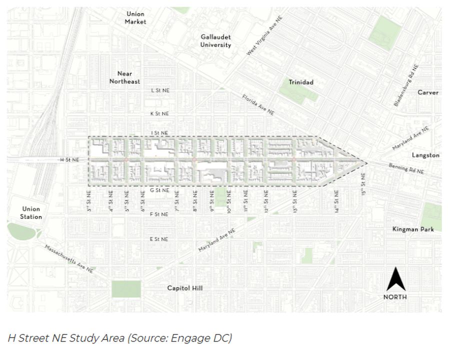
The D.C. Office of Planning (OP) in January 2026 launched the H Street Land Use and Market Study (Study), a new planning initiative focused on the H Street NE corridor between 3rd and 15th Streets NE. The Study will examine land use, public space and economic development conditions along this key corridor and identify policies and strategies to support its long-term vitality.
For those with property interests, development plans or leasing strategies within the Study area, this Study represents an important opportunity to engage early in a planning process that may influence future zoning approaches, public realm investments and market positioning.
Study Objectives
The Study is intended to:
- support diverse and resilient retail with both existing and new businesses
- bolster the corridor's identity as a destination for arts and culture
- create a land use strategy that guides mixed-use development
- design people-centered public spaces in strategic locations
These objectives signal a comprehensive review of both regulatory and placemaking strategies. The outcome may shape not only development patterns but also streetscape design, public space activation and the corridor's economic identity.
Why Now?
H Street NE is one of the District's most significant east-west corridors and has long served as a commercial hub for retail, dining, nightlife and cultural uses. OP previously completed a planning study for the corridor in 2004. In the 20 years since, the area has experienced substantial mixed-use development and residential growth, alongside evolving retail conditions.
At the same time, the corridor has faced challenges, including increased retail vacancies and turnover, as well as public spaces that remain underutilized or lack cohesive activation strategies. The Study intends to respond to these changing market and land use conditions and position H Street for positive future growth.
For prospective projects, the Study could inform future land use recommendations, zoning updates, ground-floor use expectations and public space improvements.
Upcoming Public Engagement: March 7, 2026, Open House
OP is hosting a public open house to kick off engagement on March 7, 2026, from 1 p.m. to 3 p.m., at the Sherwood Recreation Center, located at 640 10th Street NE. Attendees may walk in at any time to learn about the Study, speak with the project team and share feedback through interactive prompts. Register to attend, or email questions and comments about the Study.
Planning Timeline
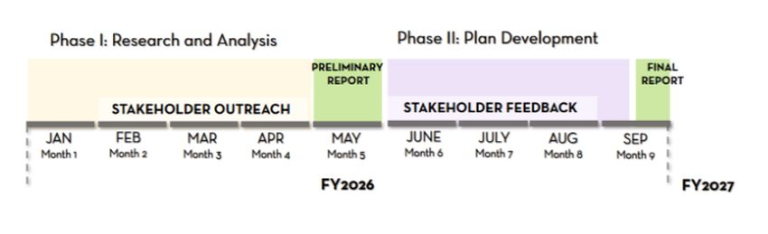
The planning process is anticipated to run through September 2026 and will include multiple engagement points as follows:
Phase I: Research and Analysis (January 2026 – April 2026)
- market and land use analysis
- stakeholder outreach
- public engagement
- issuance of preliminary report, with initial recommendations in May 2026
Phase II: Plan Development (June 2026 – September 2026)
- refinement of land use and public space strategies
- stakeholder feedback period
- issuance of final report anticipated in September 2026
Early participation during Phase I may be particularly impactful, as it will help shape the recommendations that inform Phase II plan development.
Why Engagement Matters
Corridor-level studies often inform subsequent zoning updates, small area plan amendments, public realm improvements and capital investments. They can influence:
- height and density proposals
- ground-floor retail expectations
- design standards
- public space requirements
- arts and cultural use policies
- incentives for mixed-use or adaptive reuse projects
The content of this article is intended to provide a general guide to the subject matter. Specialist advice should be sought about your specific circumstances.
[View Source]